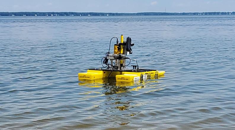
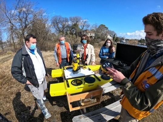
An interdisciplinary team prepares to deploy the Hydrone to help the town of Colonial Beach on the Northern Neck of Virginia understand how its shoreline has changed.
For centuries, a cartographer's toolbox was stocked with compasses, protractors, pencils and telescopes. But today's modern mappers have sophisticated toolboxes equipped with drones that, by air and by sea, can accurately capture the shifting sands beneath the water.
At Old Dominion University, researchers are using drone technology to study what can't be seen from the surface, collecting information that can help build resilience in coastal communities. This summer, researchers deployed the ODU Hydrone to map a shoreline in the Northern Neck.
The Hydrone is an example of a marine autonomous system, able to use sensors to collect and update critical environmental, infrastructure or navigation data that "smart communities" can use in their planning.
The potential uses of a water-based drone are numerous, and researchers from ODU spent the summer exploring the many ways the autonomous surface vessel (ASV) can collect important and timely information.
For example, the echosounder on the Hydrone can map navigation channels that could be obstructed by debris after a coastal storm, helping ports and recreational boaters know when it's safe to resume activity.
The Hydrone's camera system can collect photographs and video to conduct rapid damage assessment or collect baseline information on shoreline structures, such as docks, boats and buildings, which can then be fed into geographic information system (GIS) databases and emergency operations plans.
Emergency responders can use the Hydrone to inspect potential hazardous spills or render assistance while minimizing human risk.
Researchers are also exploring additional capabilities to answer key questions about water quality and assess red tides and algae blooms. The information gathered could advance predictive planning.
With support from the Resilience Adaptation Feasibility Tool (RAFT) program, the Commonwealth Center for Recurrent Coastal Flooding (CCRFR) and the Virginia Institute for Spaceflight & Autonomy (VISA), an interdisciplinary team collaborated over the summer to help the town of Colonial Beach on the Northern Neck of Virginia understand how its North Beach shoreline has changed.
The team included Tom Allen, a geography professor who works with the Institute for Coastal Adaptation and Resilience (ICAR); Thomas Alberts, a professor of mechanical and aerospace engineering; and George McLeod, director of geospatial and visual systems for Information Technology Services. Under their direction, the Hydrone gathered data as it bobbed on the waves, while a small unmanned aerial systems (sUAS) drone zipped above - effectively working as a team to document the shoreline.
The drone mapping provided updated aerial imagery for digitizing the current shoreline, supplementing aerial photography of the shoreline going back to the early 1990s. The shorelines were mapped and measured using an algorithm to capture the shoreline change rates by meters per year of erosion or deposition. Professionals working in coastal management regularly use two-dimensional data, but the ODU team was able to augment that data with 3-D digital elevation models (DEM) collected from the drone and prior aerial light detection and ranging (LiDAR) laser mapping.
This showed how the shoreline had changed and provided the 3-D volume of transported sand. After examining the patterns of sediment dynamics, the team determined further 3-D bathymetric mapping - measuring the depth of water - was needed to assess onshore-offshore sediment changes. The Hydrone was deployed to map the depths off the beach, traveling several hundred meters out to measure changes in volume. Results suggest areas of stability, erosion and deposition, providing data that can be used to refine predictions of shoreline change, breaking waves and potential adaptations the town could consider.
In August, the team met with Colonial Beach Mayor Robin Schick and town staff to deploy the Hydrone, demonstrating how to drive it both remotely and autonomously. ODU students Rob Stuart, an engineering major responsible for leading Hydrone technology, and Alex Garnand, a graduate student in ocean and earth sciences focusing on shoreline-change analytics, collaborated on collecting and processing data, and conducting spatial analysis in a GIS.
"Tom Allen and his team's investigations along the Colonial Beach shoreline have brought enlightening evidence to our long-term erosion issues," Schick said. "With his help, we are hoping to finally secure much-needed solutions for our residents and protect our invaluable environment."
Their work highlighted the efficiency and accuracy of the Hydrone to collect simultaneous GPS navigation and water depth measurements. The results also showed the value of using additional technology, including 360-degree LiDAR to avoid collisions with crab pots, buoys or boats, and a gimbal-mounted GoPro camera to visualize real-time and subsequent mapping of coastal features.
This project showcases the value of interdisciplinary collaboration, research and education among geography, engineering and ocean/earth sciences. Such partnerships have already opened doors to the private sector and commercialization efforts of companies working with the ODU OpenSeas Technology Innovation Hub and regional entrepreneurial startups to develop tech solutions for coastal resilience.
"Their bathymetry testing is Virginia education and technology at work for our localities," Schick said. "This program will benefit waterfront communities across the Chesapeake Bay region tackling these same resiliency issues."
The team is preparing a final report and presentations for the upcoming American Geophysical Union (AGU). The public can see the Hydrone on exhibit during the upcoming "Museum of the Moon" exhibition, exploring the many impacts of the moon, including tidal flooding, at the Barry Art Museum, from Oct. 15 to 17.