
Tom Allen

Nicole Hutton
By Amy Matzke-Fawcett
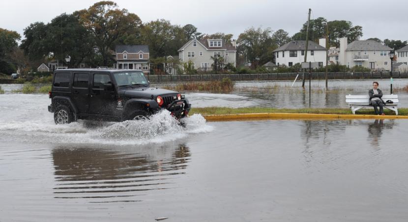
Old Dominion University researchers have partnered with a local Native American tribe to address sea level rise on a reservation.
Assistant Professor Nicole Hutton and Professor Tom Allen, both in the Department of Political Science and Geography in the College of Arts and Letters, received a Natural Hazards Center's Mitigation Matters Research Program grant to use a participatory mapping process. This helped them assess how the Pamunkey Tribe perceives its traditional resources in light of flooding and sea level rise on its lands near West Point in King William County. Members of the tribe participated in surveys and used online maps to mark areas of concern for potential erosion, flooding and habitat loss, including the potential loss of historically important sites.
The plan was to do focus groups and collect oral histories in person, but due to COVID-19 precautions, data collection was moved to mail surveys with online data entry. The grant was used to reimburse tribal consultants and participants for their time and effort in the data collection.
"Geospatial technology has spurred a wider use of public participation in a variety of communities and contexts, such as environmental justice and resilience to climate change," Allen said. "Using online maps and interactive visualizations to collect concerns and share information democratizes the situation. We foresee this technology and intentional, 'co-production' of knowledge afforded by these techniques to be increasingly used as climate change-related changes arise."
The project adapted online mapping and prior work of the Commonwealth Center for Recurrent Flooding Resilience, a joint project between ODU, William & Mary and the Virginia Institute for Marine Science, to assess and possibly inform the tribe's awareness of hazards related to sea level rise. The project also demonstrates interdisciplinarity, drawing upon coastal sea level science, geospatial technology and the human dimensions of climate change that are a focus of Old Dominion's Institute for Coastal Adaptation and Resilience, Allen said.
The data collected will inform a hazard mitigation plan and grant applications for structural and natural flood prevention measures to be developed by tribe members. The tribe is recognized at both the state and federal levels, which would allow the data to inform both.
"Using GIS to visualize mitigation priorities can increase the integration of tribal input into broader planning efforts in the region," Hutton said.
Although some efforts, such as living shorelines, bulkheads and riprap have been have been installed in recent years, and irrigation ditches have been in place for hundreds of years, areas of concern for flooding and loss still include homes, fishing huts and historic burial grounds. A story map of the data collected is available.