

Does Virginia have a "Tornado Alley?"
The infamous nickname for a region overlapping several Great Plains states west of the Mississippi River was coined in 1971 by Allen Pearson, former director of the National Severe Storms Forecasting Center. The collision of warm, moist air from the Gulf of Mexico with cold, dry air from Canada and the U.S. Northwest has spawned many tornadoes with catastrophic impacts to property and life.
Recent weather patterns and climate science suggest Tornado Alley has moved; data show increased storms likely to spawn tornadoes in Deep South states like Alabama and North Carolina.
This shift inspired Tom Allen, professor in Old Dominion University's Department of Political Science and Geography, to consider whether our state has a geographic region more prone to tornadoes.
"We thought we would explore the National Weather Service's data for patterns and trends in Virginia," Allen said.
In the study, done for Severe Weather Awareness Week this spring, Allen and research staff in ODU's Center for Geospatial Science, Education and Analytics (GeoSEA) analyzed nearly 70 years of tornado records for the Commonwealth.
Using data from National Oceanographic and Atmospheric Administration's Storm Prediction Center, they mapped locations in Virginia that had experienced the strongest tornadoes, those with the greatest width and longest on-ground track length.
"With these geographic and characteristic identifiers, we were able to leverage GIS (geographic information system) and Esri's ArcGIS Pro software to create data layers to visualize areas of Virginia that have seen especially strong and long-tracking tornadoes," said Christopher Davis, GIS analyst with GeoSEA.
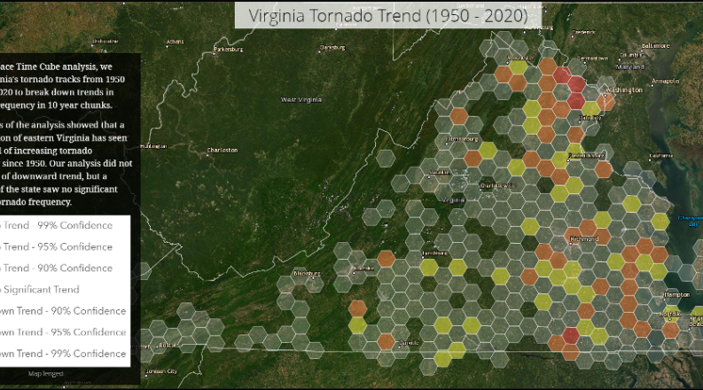
Using a spatial analysis technique known as a "Space-Time Cube," the research team analyzed the frequency of tornadoes in Virginia in 10-year chunks. This allowed researchers to deduce that tornado frequency has been increasing in certain areas since 1950.
Ultimately, the research ascertained that if there is a Tornado Alley in Virginia, it is clustered in the lower-lying portions of the state south of Richmond, comprising the Piedmont geographic region, east to Virginia's Fall Line.
"Our spatial analysis suggests there are significant patterns and that these could inform forecasting and potentially watch and warning messaging for the National Weather Service and emergency managers," Allen said.
The ODU geographer urged Virginians to keep a "weather eye" during outdoor activities, check forecasts, activate automated alerts on their phones and follow the advice of emergency management professionals.
Virginians are most likely to see tornadoes in spring and mid-to-late fall, but they can occur at any time of year.
For more information about the ODU Tornado Alley research, please click HERE.