Coastlines
Coastlines are formed where water meets the land; they are very dynamic features. The primary force along a coastline is the ocean which acts to erode, transport and deposit sediment.
Water in the ocean is in motion. Water in the ocean moves due to wind blowing across its surface and differences in density from temperature and salinity.
On the surface, water movement is in the form of waves. Waves in the ocean transfer energy through the water. The water itself is actually moving in an orbital pattern in a circle and does not move laterally with the wave; it only seems that the water is moving laterally.
Water moves from place to place because of currents, NOT waves.
|
Crest: |
The high point of the wave |
|
Trough: |
The low point of the wave |
|
Wave Height: |
Distance from Crest to Trough |
|
Wave Length: |
Distance from Crest to Crest |
|
Wave Depth: |
The depth to which the wave-form extends; calculated as 1/2 the wavelength |
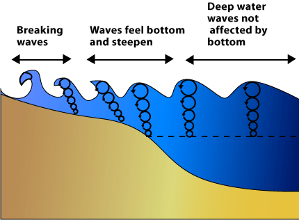
As a wave (energy propagation) travels across the ocean, it moves closer to the coast. As it approaches the shore, the underside of the wave-form "feels" the bottom of the seafloor and starts to drag. It also is "pushed up" which forms a breaking wave.
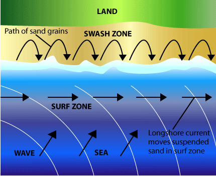
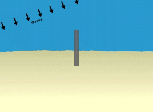
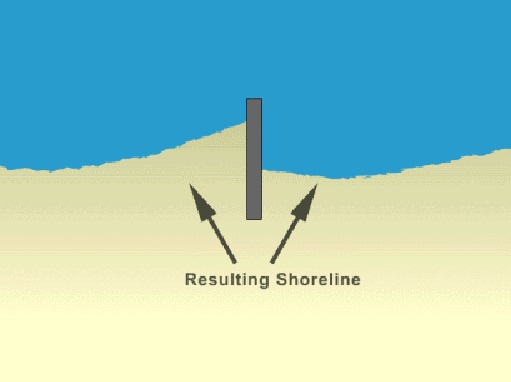
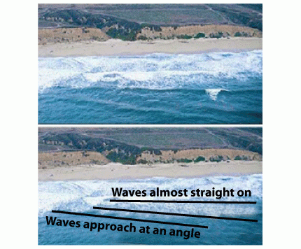
As the wave approaches the shore, the wave is bent or refracted as the leading edge slows in the shallows. This refraction forms a current that moves parallel to the coastline and is known as longshore drift or longshore current. The longshore current is an active component of coastal erosion, transportation and deposition.
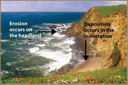
In general, waves and longshore currents act to straighten a coastline, eroding along areas that jut out and depositing along areas that indent.
Erosional Features
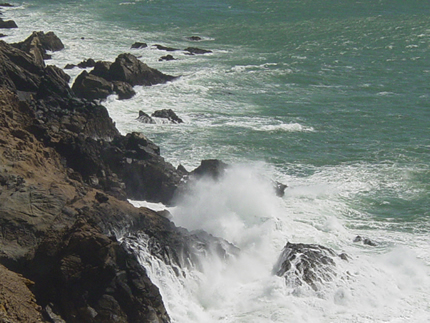
Many erosional features can be found along a coastline. Waves erode rock material through the hydraulic action of pounding surf. Longshore currents erode unconsolidated material in much the same manner as a stream. The velocity of the longshore current determines the amount of material that can be carried by the longshore current.
|
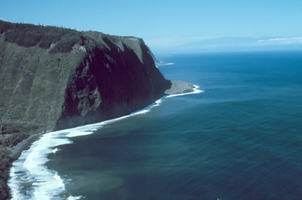
Sea Cliffs: On a rocky coastline, the ocean erodes rock material landward forming steep cliffs. |
|
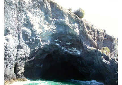
Sea Caves: In areas of headlands or rocky coasts, waves will pound rock units and erode them back landward. Oftentimes, this forms a cave at the base of a sea cliff. |
|
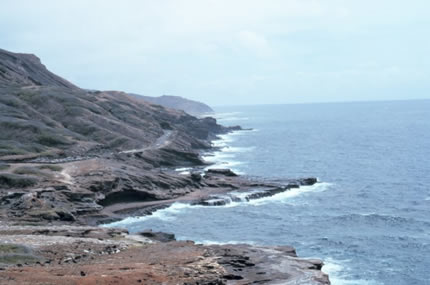
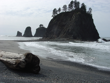
Wave Cut Platforms: As wave action pounds a coastline, the rock will be eroded back landward forming a shelf type feature along the shoreline. |
|
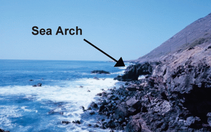
Sea Arch: Sea caves eroded into a headland connect forming an arch. |
|
Sea Stack: Rock promontory left when the top of a sea arch collapses. |
Transportation and Deposition:
The primary agent of transport along a coastline is longshore current. The longshore current carries millions of tons of sand along a beach every year.
The sand is moved along in a zig-zag pattern. Wave action moves individual sand grains onto and off of the beach as the long shore current moves the sand down the beach.
If the longshore current slows, deposition will occur. Several features that result from the action of tranport and deposition include:
|
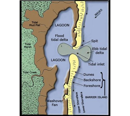
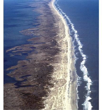
Barrier Islands/Barrier Bars: Large strips of sand, offshore from and parallel to the coast that are the result of deposition. The Outer Banks of NC are an example of a barrier island. |
|
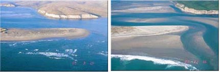
Spit: If longshore current is slowed as it flows past an inlet, sand will be deposited. This finger of sand extends out into the water and builds over time. |
|
Baymouth Bar: A sand barrier that cuts a bay off from the ocean. Longshore current flowing past an inlet deposits sand at the mouth of the inlet and over time can cut this inlet off. |
|
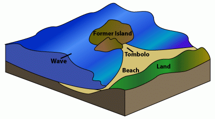
Tombolo or tied island: Offshore islands or sea stacks cause wave refraction that causes deposition landward of the sea stack or island, eventually connecting the island to the mainland. |
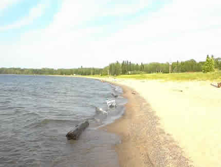
The Beach
The beach is the best known feature on a coastline. It is defined as a strip of unconsolidated material (usually sand or gravel) bordering the coastline. A beach is divided into distinct zones:
- Backshore: Area that extends from the high-tide mark to the farthest extent of water during a storm event. This area is dry except during storms.
- Foreshore: Area between the high-tide and low-tide mark. This area is alternately submerged and dry.
- Offshore: Area from low-tide mark to a depth of about 30 feet. Although this area is submerged, the sediment in this area is still part of the beach and will move onto and off of the beach between winter and summer.
|
Beaches change with the seasons.
Summer Beach: During the summer, wave action is less vigorous and sediment is moved up onto the beach from the offshore portion. This gives the beach a flattened, more gentle profile.
Winter Beach: During the winter wave action is more vigorous and sediment moves off of the beach into the offshore area. This gives the beach a steeper profile. |
|
Sand is constantly moving onto and off of a beach. An example is a grain of sand. Wave action pulls the sand grain out into the surf zone. Here it is picked up by the longshore current and moved down the beach.
Wave action then pushes this grain back onto the beach, but farther down the beach from where it started. The sand grain has moved in a zig-zag pattern.
The longshore current carries an approximate volume of sand. Wave action is constantly moving individual sand grains onto and off of the beach. Unless some force changes the velocity of the longshore current, there is no net erosion or deposition on the beach.
If the velocity of the longshore current decreases (as when it passes an inlet), deposition occurs. If velocity of the longshore current increases, erosion occurs.
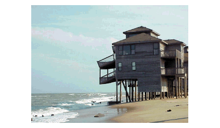
In many areas along the East coast of the United States beach erosion is an important concern.
Structures that manipulate the longshore current can deter erosion and even encourage deposition.
Strategies for living on a shrinking beach include:
- Groin: A barrier built out from the shoreline that acts to intercept the longshore current. Deposition will occur because the current is slowed, however, erosion will increase after the current passes by the groin giving the shoreline a scalloped appearance.
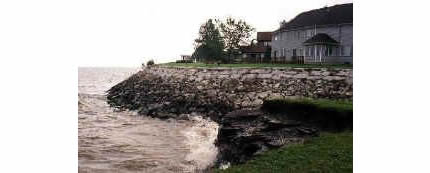
- Sea Wall: A feature built along the shoreline to keep waves from moving up the beach. This protects structures built behind the sea wall, but encourages beach erosion because it concentrates wave action at the base of the sea wall causing a scouring of the beach.
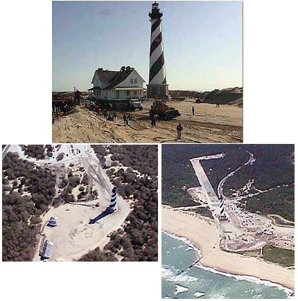
- Relocation: Traditionally, structures along the shoreline were moved as ocean waves encroached. Cape Hatteras Light was threatened and moved 1500 feet inland.
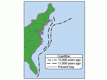
Sea Level Change: Sea level has risen and fallen many times during the geologic past. Also, the land surface can be uplifted or it can subside. The result is a changing sea level along the coastlines. Sea level can change locally or worldwide.
Eustatic sea level changes are sea level changes that are world-wide. They are caused by:
- Climate Change: increase/decrease of glacial ice can cause sea levels to rise and fall
- Sea Floor Spreading: Increase in rate of spreading increases sea level
- Warming oceans: Warming oceans expand and causes sea levels to rise
Local sea level changes are caused by:
- Isostatic uplift: the land rebounds when glaciers melt
- Regional tectonic uplift: isolated area of uplift caused by plate movements
- Land subsidence: increased sedimentation or withdrawal of groundwater or oil deposits can cause land surface to sink
Emergent/Submergent Coastlines
Emergent Coastlines: coastlines that appear to be undergoing a drop in sea level. Common features include:
� Wave cut platforms
� Sea caves
� Sea arches
Submergent Coastlines: coastlines that appear to be undergoing a sea level rise. Common features include:
� Drowned river valleys (estuaries)
� Fiords